✕
TopYou Categories

Top 50 Geography Memes

RANKING FOR BEST Geography Meme

Hello there, fellow geography enthusiasts and meme connoisseurs! Welcome to my very own space on the wonderful web, “Geography Memes Ranked,” exclusively on TopYouLar.com. Here, it’s all about blending humor with the fascinating world of geography. As the ultimate curator of this niche, my sole mission is to bring a smile to your face while perhaps sneaking in a geography lesson (or two) through the universal language of memes.

Navigating through the endless sea of content on the internet, I’ve meticulously gathered, sorted, and ranked the crème de la crème of geography memes just for you. This is your go-to destination to discover the top 50 memes in the geography category. Whether you’re a student trying to procrastinate, a teacher looking for a way to spice up your lessons, or simply a geography buff riding the meme wave, I’ve got something special for everyone.

On “Geography Memes Ranked,” the memes you’ll find are anything but ordinary. From humorous takes on geographic misconceptions and playful jabs at countries’ shapes and sizes, to witty observations about geographical phenomena, these memes have been voted to the top by a community of geography meme lovers just like you. The ranking is dynamic, reflecting the ever-changing pulse of what the geography meme community finds hilarious, insightful, or just plain silly.

Each meme is a ticket to a joyous journey around the world, from the comfort of your screen, offering laughs that span continents and oceans. I take pride in the fact that this isn’t just a compilation but a curated experience. It’s a celebration of the quirks, oddities, and wonders of our world, captured through the lens of humor.

So, whether you’re here to find a chuckle, check out which memes are currently ruling the geography roost, or simply to procrastinate, “Geography Memes Ranked” on TopYouLar.com is your ultimate destination. Dive in, vote for your favorites, and let’s keep the spirit of geographical exploration alive, one meme at a time. Remember, in the world of geography memes, every click is a journey, and every laugh is a lesson. Welcome aboard, and enjoy the ride!
1
YOUR #
Votes: 0
Pop: 0
TopU Score: 0
✕
TopU: 0
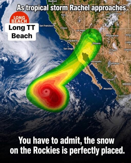
Current Event Memes, Dirty Mind Memes, Double Meaning Memes, Funniest Memes, Geography Memes, Hurricane Memes, Innuendo Memes, Map Memes, News Memes, NSFW, Penis Memes, Play on Words Memes, Weather Memes, A satellite-style weather map of the western United States and Mexico shows a brightly colored storm forecast overlay stretching from the Pacific Ocean toward the Southwest. The green, yellow, orange, and red storm shape curves upward toward Arizona and Southern California in a way that is unmistakably suggestive, while city labels like Long Beach, San Diego, Phoenix, Las Vegas, and Denver anchor it in a real map setting. Large white text at the top reads “As tropical storm Rachel approaches,” and a Long Beach label on the left is comically altered into “Long TT Beach.” At the bottom, the caption points out that “the snow on the Rockies is perfectly placed,” drawing attention to the white mountain snow near Colorado as part of the visual gag.
✕
1
2
3
4
5
6
7
8
9
10
All Time Rank
#10
All Time Rank
#9
All Time Rank
#8
All Time Rank
#7
All Time Rank
#6
All Time Rank
#5
All Time Rank
#4
All Time Rank
#3
All Time Rank
#2
All Time Rank
#1
2
YOUR #
Votes: 0
Pop: 0
TopU Score: 0
✕
TopU: 0
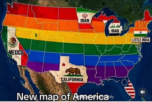
American Memes, Funniest Memes, Geography Memes, Immigration Memes, Map Memes, Mexican Memes, Muslim Memes, Offensive Memes, Political Memes, Stereotype Memes, Stereotyping Memes, The meme shows a colorful, altered map of the United States, with state outlines still visible but the country visually repainted and relabeled as if it has been divided into foreign or culturally symbolic regions. Large labels mark parts of the map as “IRAN,” “IRAQ,” “LITTLE INDIA,” “MEXICO,” and “CALIFORNIA,” using flag imagery from those places, while Texas is oddly filled with California’s bear flag design. Across the bottom, bold white caption text reads “New map of America.” The overall look is intentionally chaotic: a familiar U.S. map is turned into a patchwork of national flags, cultural references, and exaggerated regional identity jokes.
✕
1
2
3
4
5
6
7
8
9
10
All Time Rank
#10
All Time Rank
#9
All Time Rank
#8
All Time Rank
#7
All Time Rank
#6
All Time Rank
#5
All Time Rank
#4
All Time Rank
#3
All Time Rank
#2
All Time Rank
#1
3
YOUR #
Votes: 0
Pop: 0
TopU Score: 0
✕
TopU: 0
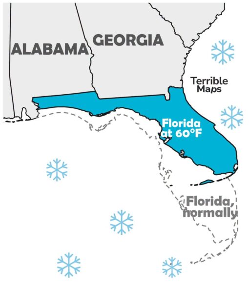
Florida Memes, Funniest Memes, Geography Memes, Map Memes, Stereotype Memes, Weather Memes, Winter Memes, A simplified map of the southeastern United States shows Alabama and Georgia in gray, while Florida is highlighted in bright blue—but shifted northwest so that it stretches along the Gulf Coast under Alabama and Georgia. A dashed outline of “Florida, normally” appears farther southeast in its usual peninsula shape, suggesting the state has physically moved away from its regular warm-weather position. Several blue snowflake icons float around the map, reinforcing the idea of cold weather. The label “Florida at 60°F” sits on the displaced Florida shape, while “Terrible Maps” appears nearby like a faux map-brand watermark.
✕
1
2
3
4
5
6
7
8
9
10
All Time Rank
#10
All Time Rank
#9
All Time Rank
#8
All Time Rank
#7
All Time Rank
#6
All Time Rank
#5
All Time Rank
#4
All Time Rank
#3
All Time Rank
#2
All Time Rank
#1
4
YOUR #
Votes: 0
Pop: 0
TopU Score: 0
✕
TopU: 0
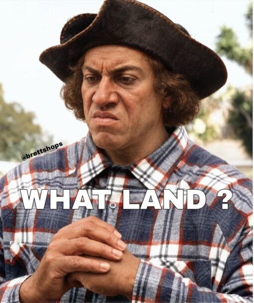
American Memes, Confused Memes, Funniest Memes, Funny Text Memes, Geography Memes, History Memes, Political Memes, A close-up shows a man in an old-fashioned tricorne-style hat and plaid shirt, staring downward with a deeply skeptical, almost disgusted expression. His hands are clasped in front of him, which makes him look like he is processing some unbelievable information in real time.
✕
1
2
3
4
5
6
7
8
9
10
All Time Rank
#10
All Time Rank
#9
All Time Rank
#8
All Time Rank
#7
All Time Rank
#6
All Time Rank
#5
All Time Rank
#4
All Time Rank
#3
All Time Rank
#2
All Time Rank
#1
5
YOUR #
Votes: 0
Pop: 0
TopU Score: 0
✕
TopU: 0
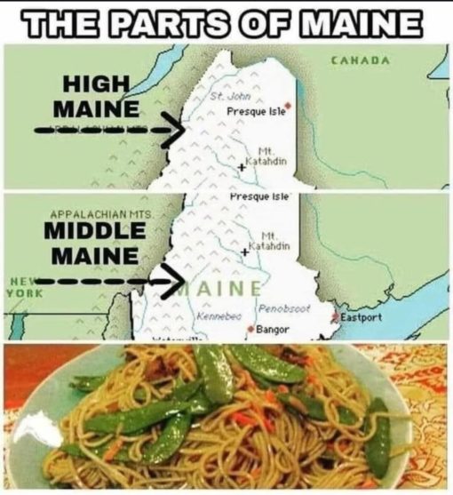
Dad Joke Memes, Food Memes, Funniest Memes, Geography Memes, Play on Words Memes
✕
1
2
3
4
5
6
7
8
9
10
All Time Rank
#10
All Time Rank
#9
All Time Rank
#8
All Time Rank
#7
All Time Rank
#6
All Time Rank
#5
All Time Rank
#4
All Time Rank
#3
All Time Rank
#2
All Time Rank
#1
Top 3
Top 50 Geography Memes
#1#1
Current Event Memes, Dirty Mind Memes, Double Meaning Memes, Funniest Memes, Geography Memes, Hurricane Memes, Innuendo Memes, Map Memes, News Memes, NSFW, Penis Memes, Play on Words Memes, Weather Memes, A satellite-style weather map of the western United States and Mexico shows a brightly colored storm forecast overlay stretching from the Pacific Ocean toward the Southwest. The green, yellow, orange, and red storm shape curves upward toward Arizona and Southern California in a way that is unmistakably suggestive, while city labels like Long Beach, San Diego, Phoenix, Las Vegas, and Denver anchor it in a real map setting. Large white text at the top reads “As tropical storm Rachel approaches,” and a Long Beach label on the left is comically altered into “Long TT Beach.” At the bottom, the caption points out that “the snow on the Rockies is perfectly placed,” drawing attention to the white mountain snow near Colorado as part of the visual gag.
American Memes, Funniest Memes, Geography Memes, Immigration Memes, Map Memes, Mexican Memes, Muslim Memes, Offensive Memes, Political Memes, Stereotype Memes, Stereotyping Memes, The meme shows a colorful, altered map of the United States, with state outlines still visible but the country visually repainted and relabeled as if it has been divided into foreign or culturally symbolic regions. Large labels mark parts of the map as “IRAN,” “IRAQ,” “LITTLE INDIA,” “MEXICO,” and “CALIFORNIA,” using flag imagery from those places, while Texas is oddly filled with California’s bear flag design. Across the bottom, bold white caption text reads “New map of America.” The overall look is intentionally chaotic: a familiar U.S. map is turned into a patchwork of national flags, cultural references, and exaggerated regional identity jokes.
Florida Memes, Funniest Memes, Geography Memes, Map Memes, Stereotype Memes, Weather Memes, Winter Memes, A simplified map of the southeastern United States shows Alabama and Georgia in gray, while Florida is highlighted in bright blue—but shifted northwest so that it stretches along the Gulf Coast under Alabama and Georgia. A dashed outline of “Florida, normally” appears farther southeast in its usual peninsula shape, suggesting the state has physically moved away from its regular warm-weather position. Several blue snowflake icons float around the map, reinforcing the idea of cold weather. The label “Florida at 60°F” sits on the displaced Florida shape, while “Terrible Maps” appears nearby like a faux map-brand watermark.
American Memes, Confused Memes, Funniest Memes, Funny Text Memes, Geography Memes, History Memes, Political Memes, A close-up shows a man in an old-fashioned tricorne-style hat and plaid shirt, staring downward with a deeply skeptical, almost disgusted expression. His hands are clasped in front of him, which makes him look like he is processing some unbelievable information in real time.
Dad Joke Memes, Food Memes, Funniest Memes, Geography Memes, Play on Words Memes
© 2026 TopYoular Site Map | privacy policy | Terms of Service